Uninstall QGIS in Windows and Linux
To uninstall QGIS on Windows can be done in the Control Panel-Add/Remove Program, and remove registrynya on:
\ \ HKEY_CURRENT_USER \ Software \ QuantumGIS \ qgis
and on Linux stored in the registry:
$ HOME / .config / QuantumGIS / qgis.conf
This is stored in the registry settings for display, WMS and PostGIS connection, which can be changed manually.
Monday, October 13, 2008 | 0 Comments
QGIS Installation (Linux-debian)
QGIS installation on Linux as Ubuntu, can be done as follows:
1) From the terminal run the command:
sudo etc / apt / sources.list
2) If using the version of Hardy Heron, then add the following sentence at the end of the source file list:
deb http://ppa.launchpad.net/qgis/ubuntu Hardy main
Save these changes, and then run the terminal command:
sudo apt-get update & & sudo apt-get install qgis
Then the window will appear to install QGIS same as in windows installation
Monday, October 13, 2008 | 0 Comments
QGIS Installation (Windows)
To perform the installation in Windows QGIS follow several steps:
1) Double click the icon QGIS.exe with a large 73.3 MB.
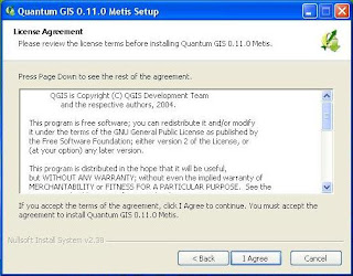
2) The new window will appear that contains the welcome speech. Here, the version shown QGIS that you install the version 0.11.0 with the code name Metis project. Then select Next.

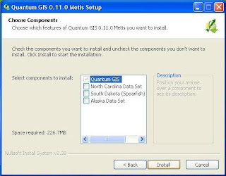
4) Then you are asked to set the location of the installation. It is recommended to use a fixed location that has been written. Also shown that large files will be saved to your computer is 226.7 MB. Then select Next.
 5) Finally you will be shown tambaha window to select the components of the data sample. To ignore it at this time, because to get the components that require an internet connection. Choose the Install button to start the installation.
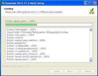
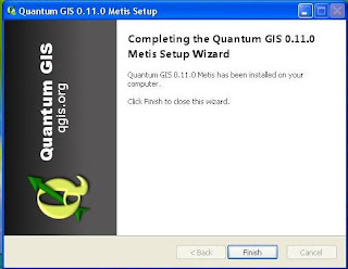
 6) Then, after terekstrak files to the location of the installation, then QGIS window will display the cover, which means that you have successfully installed QGIS.

Monday, October 13, 2008 | 0 Comments
Open Source GIS (Part.2)
QGIS
QGIS is one of GIS software with open source licensing under the GNU General Public License (GPL). That means that the source code used in building applications can we learn and change, and we can get for free. Unlike with commercial software in general, where the source code is closed so that the user can not develop their own application in accordance morning. QGIS is an abbreviation of Quantum Geographic Information System. GIS software is made starting in May 2002 and has been defined as projects in the SourceForge in June 2002. One of the advantages of this software QGIS is a lightweight and user-friendly. QGIS also has some version suitable with the platform, so it can run on Windows, Linux, and OSX. QGIS built using Qt and C + +. Early goal from making QGIS only as a viewer data only, but added with a growing variety of other plugin that works as a database management, spatial analysis, or to attach the display, so now QGIS not powerfull compared to other software such as ArcView GIS, or GRASS.
Monday, September 08, 2008 | 0 Comments
Open Source GIS (Part.1)
In addition QGIS still many other GIS software that can compete with commercial GIS software, which is currently dominated by ESRI. Open Source Applications (OS) SIG itself can be categorized into 2, namely the Library SIG OS and application OS SIG. Library GDAL such as GIS, the OS / ORG, Proj4, GEOS, GML4J, JTS, GeoTools, created with the goal of building a module in the application. GIS applications OS preferable to the interests of users in the GIS process. OS GIS applications can be divided into 3 types:
1) Desktop Applications. Such as: QGIS, GRASS, MapWindow, Thuban, OpenMap, ILWIS, etc..
2) Web-based applications. Such as MapServer, MapGuideOS, GeoServer, and DeeGree
3) Applications Database. Such as PostGIS
Monday, September 08, 2008 | 0 Comments
GIS Data and It's Projections (Part.2)
GIS maps produced is a projection from the earth surface geometry data with the actual situation in the 2.5 - 3 dimensions into 2-dimensional. Changes in the dimensions of this is done with little distortion, so the results may be achieved is not too much different with the form, distance and the actual area. There are various types of projection from the surface of the earth, roughly spherical flat as a flds cylinder / tube (cylindrical), cone (conical), flat field (zenithal) and composition (arbitrarry). However, the accuracy is close to the projected composition. Projection is obtained through the calculation.
In Indonesia, generally using the projected composition of the WGS-84 (World Geodetic System) and UTM (Universal Transverse Mercator). UTM projection is a projection map, which many in the select and use in the mapping activities in Indonesia because the value of the ideal syarat2 meet with the appropriate form, location and area of Indonesia. UTM projection in the entire surface of the earth is divided over the 60 called by the UTM zone. Each zone is limited by two meridian at 6 ° meridian and have their own midst. For areas of Indonesia is divided into nine zones UTM, starting from the meridian 90 ° with BT to 144 ° with BT limit pararel (latitude) 11 ° to 6 ° LS LU. Thus, starting from the Indonesian region a zone 46 (central meridian 93 ° BT) to zone 54 (central meridian 141 ° BT).
Saturday, September 06, 2008 | 0 Comments
Rasterization and Vectorization
In some GIS software, there are facilities to change the model data vectors into raster data (Rasterization) or otherwise change the model of raster data into the data vectors (Vektorization). This process is usually useful for instance when we will change the contours of a line (raster) into vector or change the regional map vectors into the surface raster. However, this process usually depends on the resolution of the original data.
Friday, September 05, 2008 | 0 Comments

